S/V INTREPID II - Cape Dory Intrepid 40

My photo
Intrepid II is a Cape Dory Intrepid 40 sailboat, hull #2, designed by Chuck Paine and discovered by the Captain in Blue Hill Maine in 2006. The crew are Kelly (Captain) and Carol (Admiral and Blogger). In 2009 INTREPID II embarked on her West Coast journey from Victoria to San Francisco, the Baja Sur Peninsula and into the Sea of Cortez. In 2010/2011, we sailed from Guaymas, south to Bahia Banderas and back. In 2011/2012 we left Guaymas, headed south to La Paz, spent three weeks at anchor on our northward journey and rested on the hard in San Carlos. Her 4th, 5th and 6th seasons were Boat Projects related. Season 7 - an incredible amount of boat work - but no cruising. Season 8 - Tropical Storm Sergio toppled Intrepid II in San Carlos dry storage. A disappointing season of serious and costly repairs. Season 9 - continuing those repairs and still hopeful for cruising.

July 16, 2012

"Summer" in Victoria

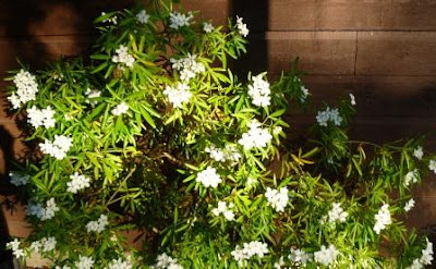
Mexican mock orange in bloom
Thanks to all of you who waited to read our 'anchorages in review' updates, which we finally completed today.  Once we arrived home it was time to tackle all our land-based projects and we're working our way through them, making time for some 'r and r' here and there.

We hear from our cruising friends as they continue their journeys, or put their boat on the hard, or head homeward to catch up with family and friends.  Family have come to visit, which was an incentive to tackle some 'spring cleaning', then enjoy being tourists with them.  It was fun to visit Fisherman's Wharf to sample Barb's Fish 'n Chips, watch the seals being fed, walk through Beacon Hill Park and relax on the deck at the end of the day.

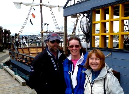
Randy, Diana and Carol at Fisherman's Wharf - could have been warmer!
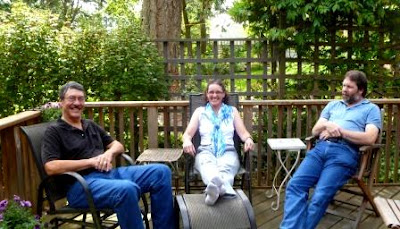
Kelly, with Diana and Randy  - enjoyed the visit!

Young deer visiting the neighbourhood
Trees have had to be cut down, flower beds weeded, grass cut, patios and decks power-washed, papers shuffled, sorted and filed. Those are on-going projects, of course. Currently we are contemplating exterior paint colours and siding options for our house; just as much to do as looking after one's boat! Victoria area has had some hot, sunny days, but we awoke on Friday to slow, deep rumbles of thunder, which is not too common in this area. That was followed by thunder showers and lightning and more showers overnight.

It's a lovely, sunny day today. We will post photos and updates from time to time as we enjoy being home.  Our fingers are crossed that all is well with our INTREPID II as she waits out the hot summer in San Carlos.  We still need to follow the lead of our two cats who know when it's time for a well-deserved nap!
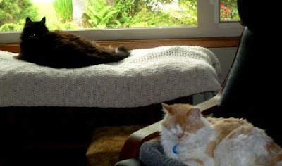
Nap time!
Cheers - have a great summer!

Anchorages in review - Bahia Santa Inez towards Santa Rosalia (April 24)

Nearing Santa Rosalia with Tres Virgenes (volcanos) in distance
[Our April 26th update from Santa Rosalia gave a brief description of our 'lumpy, bumpy' voyage over the 27 nm from Bahia Santa Inez.  Here are a few more details.]

Dropping anchor in Bahia Santa Inez basically cut our travel time in half to Santa Rosalia.  We did not have to awaken at 'oh-dark-thirty'; rather we were underway by the more reasonable 07:12 hours.  As we rounded the south point of Punta Chivato ,we were quickly  into 2 - 2.5 foot NE swells and strong current against us. No speed records set today.  Our radio reception was spotty, but we received a weather update from SV Content:  N 11 - 15 winds for the morning, with NNE 10 - 13 winds for the afternoon.  Paula and Bill had decided to cross to the mainland later that day and we wished each other safe travels.


Credit:  free whale image (Google images)
INTREPID II does a valiant job of moving through the water. She averaged 4.6  - 5.5 - 6.2 knots, motor-sailing that day as she bounced up and down and plowed through the contrary waves and current.  At one point, as Carol was below verifying our speed and course, Kelly called out "WHALE!", slowing down immediately as a large humpback, followed by dolphins, crossed our bow no more than two boat-lengths ahead.  We watched as it moved further east, then turned southward and paralleled our starboard side 100 feet away.  As it moved into a brilliant beam of sunlight we had that unforgettable picture of its massive tail flukes outlined against the sky.  [This photo was the closest we could find to recapture that moment.]

Then, while savouring that marine experience, we had to get INTREPID II back on course, continuing on our way towards the eastern side of Isla San Marcos.  Winds were NNW 10, on the nose, as we held to a 328 heading and took pictures of the changing topography of this island, which is home to a gypsum mine and a small village.

Rock formations on crest of Isla San Marcos


Pelican heading southward
There are anchorages available around San Marcos, all somewhat impacted by the noise and dusty air of the mine.  Off the northern tip, strong tidal currents are prevalent and we stayed well off the rocks and reefs as we continued our approach to Santa Rosalia.  By 11:40 we were dropping the main, putting out fenders and attempting to contact the Fonatur Marina for a slip.  No answer on VHF radio, so we kept our fingers crossed and entered the breakwater with a sharp left turn towards the docks.  From our initial visit, we knew we wanted a slip with the wider dock.  Fortunately although there were several boats tied up, we slipped into A14, starboard tie.   Engine went off at 12:09; travel time of just over 5 hours.  This time our fuel calculations showed a better result:  0.7gallons/hour; not bad for all the headwinds and adverse currents encountered that day.
Looking towards breakwater and harbour entrance (east)
Gathering up our 'important papers' we headed to the marina office.  Once we were assured there really was hot water in the showers and laundry, we paid for our moorage and set off to see the town.

PS:  For the LGD infrastructure folks, project signs are important in Baja California Sur as well.  This one is located near the central plaza and is a project for the lighting of the locomotive monument.


[This brings things back 'up to date' in a round-about way....we were able to do blog updates from Santa Rosalia on].

Anchorages in review - Bahia Santa Inez (Punta Chivato) (April 23 - 24)

Slowly working through the logbook and wx (weather) notes and enjoying revisiting our recent cruising experiences.....)
Dolphins swimming by
Sunday's Sonrisa weather forecast for Monday's planned departure was 'brisk:  NNE 15 - 19, with Tuesday promising NNE 13 - 17 knots.  Both days' wind offerings were to be 'right on the nose' for a crossing over to San Carlos and Guaymas. Stan's forecasts suggested Monday would be W 10 - 15 and Tues NW 10 - 15; better for a crossing, but 'on the nose' for continuing up the peninsula towards Santa Rosalia.  Flip a coin!  Later that hot, muggy afternoon, several boats left to anchor near the mouth of the bay at Santo Domingo for a brief rest before making their crossing.  We waited for the expected ENE 11 -14 late afternoon winds.  By 16:45 however, INTREPID II shifted position and winds filled in to N 14 -15, cooling us off somewhat.  We made our preparations to leave for 'somewhere' in the morning.

Monday morning the engine was on at 07:00 and we were away at 07:12 in the quiet, still morning.  As we turned north to head up Bahia Concepcion we were greeted by dolphins who kept us company, then bid 'adios' as we tuned up the SSB for the early bird net.  No success checking in, but we managed to do so by asking for a weather fill from Geary. That provided a chance to thank him for his hospitality when we stopped by a few days earlier.  He was predicting winds NE 9 - 11 for the morning, increasing to NNE 15 - 20 for the afternoon. This made a south facing anchorage a good option for the moment - 23 nm further.

Weather guru Geary and Kelly - visiting at El Burro Cove
Once we were passed Santa Domingo and the protection of land to the east, we felt the full effect of NE swells. The NNE winds had started blowing much earlier out in the centre of the Sea.  Kelly took over hand steering as our auto-pilot was not at its best in the roll and chop of these swells, trying to maintain a 333 degree heading.  We had the main up, jib on starboard tack and were making 7 knots. At 10:00 hours our GPS noted we had reached 27 degrees 00.10N.  We were now in the "North Sea" which is an arbitrary distinction for weather purposes.  Apparently there is a marker on shore noting this geographical spot.
Heading towards Bahia Santa Inez mid-morning
With all the 'to-ing and fro-ing, pitching and yawing' INTREPID II was experiencing, we decided to head in to the anchorage ahead to see conditions for ourselves.  Otherwise it would be a very long slog to Santa Rosalia.  This spot is known for a great shelling beach along the west side and we'd wanted to explore it.  Shortly after, we were hailed on the VHF by a voice who inquired if we'd heard the weather forecast and were familiar with this anchorage.  His information was that the wind might shift around to the SE in the evening and we would be on a lee shore.  Once we motored in behind the low headland on which a hotel is located and watched the swell and winds, we decided to stay and tucked in at 13 feet over a sandy bottom.  Engine off at 11:03 and mark the spot:  27 03.967 N 111 57.666 W.  SPOT message sent - time for lunch!
Anchored with hatches wide open - still very hot days
Hotel on south-east point
Boat launch and nearby home
That afternoon SV Content followed our track and chose to join us in the anchorage; stopping by later for a chat from the dinghy as they took Max and Emma ashore.  The helpful radio contact fellow also rowed out;  he is a local resident who enjoyed boating and tried to alert cruisers to the local conditions.  Ed had kind and admiring words for INTREPID II and joined us in the cockpit for a glass of wine as we traded stories and enjoyed the view.  
Friendly resident rowing over to visit
Disappointed, we postponed our trip to the shelling beach as we anticipated having to leave very early the next day.  Our evening was quiet, the wind stayed in the N - NE quadrant and we rolled to only a slight swell.  One ear open for shifts.   A pleasant place in the right conditions.

July 11, 2012

Anchorages in review - Bahia Santispac (April 18 - 22)

Santispac beach and restaurant
The SV Content crew arrived some hours later, as they are diligent about maintaining low revs and conserving fuel. Bill and Paula picked a spot to anchor, which we decided was even better than ours, as it offered more SE wind protection. Time to stretch legs, so we met up on the beach.  Playa Santispac is home to a restaurant formerly called Ana's (now Lupe's) as well as a campground for RVs and tents, all located just below the trans-peninsula highway which leads to Mulege.


SV Content at anchor in Bahia Santispac
There are small bays throughout the larger Bahia Concepcion, with homes and palapas scattered about.  On our first visit in 2010, we experienced the exuberance of Semana Santa , with a crowded beach, lots of activity near and on the water.  This visit was a quieter one, although the anchorage filled up in the days to come.   We slept well after the day's travels, in spite of the sound of air brakes as trucks came down the hill towards the bay.

Thursday morning we slept in and caught Geary's weather  on VHF 22 about 08:10.  Geary lives just 'down the road' at El Burro Cove.  He tapes his Sonrisa net forecast for the local broadcast and adds a details specific to Bahia Concepcion.  The temperature was rising with 87 degrees forecast and winds ESE 14 - 18.  It appeared a good day to catch a ride into Mulege as we'd been at sea for over two weeks and wanted a few fresh veggies and to top up our liquid nourishment.  Friendly folks camping in an RV, whom we'd met the night before, gamely drove the four of us the 20 miles into Mulege and drove us back as well a few hours later.  It definitely beats the uncertainty of hitch-hiking.
Towards Mulege


Great food 
We were able to provision, find that the only dive store had closed down, buy some souveneir t-shirts and enjoy a tasty lunch.  Mulege is a friendly community and we enjoyed our brief visit.   Our timing was good returning to the anchorage, as late afternoon brought NNW winds gusting up to 19 knots. That evening Kelly rowed us in against somewhat lighter winds for happy hour at the restaurant, meeting some new folks and reconnecting with Pepe, the bartender and Russ, the restaurant owner. By cruisers' midnight, after a rewarding and practical day, we found we were facing south in rolly swells; nothing we couldn't sleep through.
La Posada beach and homes
The next days were filled with boat chores, such as discovering why aren't the batteries charging? There is lots of sunshine and the solar panels are keeping busy!  We walked on the beach, took dinghy rides to La Posada which has an excellent bakery; had a splashy ride to El Burro Cove for a visit with weather guru Geary to thank him in person for all his weather forecasts, and enjoyed dinner at the restaurant.

It was HOT - the temperature reached 90 F and fans were on in the cabin.  We felt incredibly lethargic and the winds were actually welcome when they blew up in the late afternoons.  Friendly little finches sang cheerfully as they tried to nest under our mainsail cover, almost from the minute we had dropped anchor!  Soon the sail cover was bristling with every clothespin we could find to keep the openings tight.  Our fear was that if they wasted all their time trying to nest on the boat, they would lose everything once we left.
Tres amigos at La Posada Bakery
Friday evening, we were enjoying a tasty meal with Paula and Bill and our RV friends, when the crew of Keetya I walked in.  Rob and Kim had put their boat on the hard in La Paz and were driving homeward.  Some serendipity, a chance to catch up and introduce them all around. They have spent several vsits here and are right at home with the staff.  Somehow we were talked into staying longer. One more day, so we could take in the weekly Saturday bbq and dance.  Once again a good tine was had by all.  The night breezes cooperated as we rowed back to INTREPID II with music following us over the water.  There was no chance of staying awake just a bit longer to watch the meteor shower; it had reached 96 F by early afternoon and all that heat and good food and dancing made for very sleepy cruisers.
Cool clear water

Anchorages in review - to Bahia Concepcion (April 18)

Just before dawn
The forecast for Wednesday (on Tuesday) was for either ESE 15 - 20 knots (Geary's wx) or SE 10, with seas SE 1 - 2 feet and W 10 - 15 at night (Stan's wx).  We awoke at 05:30 to a 1013 bar, light SW winds 8 - 10 and a light south west swell.  Our options included Bahia Santispac in Bahia Concepcion - 55 nm, Santa Domingo - 47 nm and Punta Chivato - 56 nm.  So a planned journey of 9 or 10 hours, possibly shorter, if the SE winds cooperated with INTREPID II.   SV Dune had left much earlier; they had planned to be underway by 4:30 am.  The pre-dawn hours are special times. We had a crescent moon overhead as we raised the anchor and the main quietly, waved adios to San Juanico and headed out at 06:25.  Sunrise followed at 06:58; beautiful and peaceful as we motored northbound, passing La Ramada anchorage in 2 foot swells.  
Sunrise

Not much success with accessing weather updates on the Sonrisa net.  We were able to check in with Ellen  of SV Galatea who was net control that day.   Interestingly, she and Jim were underway, nearing San Carlos on the mainland and we could pull them in; but as we were heading closer to Bahia Concepcion and Geary's home base of El Burro Cove north west of us across a low mountain range, we had interference. About the same time, the Captain made the discovery that our batteries were not charging!  The latest challenge!

SV Content radioed us on VHF to advise they had left San Juanico as well and were about 30 minutes behind us;  they had no success hearing the weather update either.  We motored passed Punta Pulpito which was less forboding in the early light and passed the sand dunes on the north side of Punta Santa Teresa.  Mid morning brought longer swells and calmer seas, as we continued on a 327 degree heading at 6.7 knots; later an adjustment to 312 degrees around Punta Santa Teresa.  At 11:25 SV Dune called to advise they were near Bahia Concepcion, but were going to continue on to Santa Rosalia - keeners! 

Punta Pulpito off port side
Sand dunes north side of  Punta Santa Teresa


Fishing ....
The day was pleasant and sunny, the winds had not yet filled in.  It is always a mystery as to when "afternoon winds" will show up.  The current and swells were not in our favour, but you can't have everything.  Fishermen waved from their panga; a dozing seal lay on its back, flippers in the air.
Dozing seal ....
Punta Concepcion 
Now that we were closer to our destination we didn't want strong SE winds, as we prepared to turn west and then south into Bahia Concepcion and have them be on the nose.  What greeted us was a large fishing vessel at the head of the bay.
Trawler and gulls
However, with a SE 10 wind we were able to boost our speed to 7 knots with a 179 degree heading, so no complaints.  It is about an hour long trip down into the smaller anchorages of Bahia Concepcion; the depths are very shallow and this time there were tiny black flags bobbing here and there very close to the channel.  

Courtesy of Avalon Travel and Moon.com

Turning right at Punta Piedrita, we found an empty anchorage, except for one small sailboat at a mooring; the restaurant owner's vessel.  As we motored and watched for seaweed and sandy spots, the wind started to rise from the north - local conditions?  At 14:55 we were anchored in 25 feet at 26 45.819 N, 111 53.112 W after a long 9 hours, but not strenuous ones.  Later, checking our distance and fuel consumption, we we disappointed to discover we used 8.5 gallons motoring 8.5 hours. We turned our thoughts to tidying up and watching for the arrival of SV Content and then make a visit to the beach.  (Of course - it was Wednesday and "Ana's" was closed.)

INTREPID II anchored in Bahia Santispac

Anchorages in review - San Juanico and weather challenges

Thank goodness for the 'flopper stopper'
Our stay at San Juanico was overall a great one.  Although tempered by the strong winds and the ongoing need to plan ahead for a good weather window to leave for anchorages further north, we like it here.  Definitely the cruisers' conundrum:  when should we leave?

We were receiving weather reports such as:  "fresh north winds will commence in the Gulf from 26 N - 29 N by Sunday night as an inverted surface trough develops along the eastern coastal sections of the gulf with high pressure shifting closer to the Baja Peninsular from W - NW...".  

Then we'd get reports of winds to be in the W 19 -25 knots and seas WNW 4 - 7 feet at 5 seconds for that Saturday followed by NW 16 - 21 knots with seas NW 2 - 4 feet at 3 seconds for the Sunday under consideration.  The third day out (Monday) promised the strongest weather, with WNW 17 - 23  knot winds and seas 3 - 6 feet at 4 seconds.  As we've mentioned, although the winds and direction are certainly a consideration in planning our next passage, it is the 'bufaloes' or short, square waves at very short intervals, which make for lumpy, rolly, uncomfortable hours.  These waves are very effective at stopping forward motion when you finally get the sails set to head in the right direction.
[BTW:  a knot is 0.539956803456 of a km/hour]

The cruisers' nets provide us with first hand information about what folks were currently experiencing in their anchorages and passages.  A few boats in San Juanico anchorage started out on Sunday, very early, hoping to make headway long before the winds and seas built.  They had turned back and were re-anchored by the time we were having breakfast.  There was no respite that day, as the seas had not laid down overnight.  By 11:00 we had 17 - 20 knots (31 - 37 kms/hour) and white caps out in the channel, with 2 foot wind waves slapping at the hull.  Forecast was accurate!


Water bird ballet
The local wildlife were out and about in spite of the brisk conditions.  We viewed the rafts of small sea birds who floated nearby, expertly choreographed to turn and dive as one and pop up beside another vessel.  Our best guess is that they were 'Eared grebes'.  A neighbour radioed over that she had spotted a pinkish toned sea lion nearby.

On Monday, Geary's weather report advised of a 7 mb gradient in the Sea, which meant more strong winds, with a Tuesday forecast of N 13 - 17 and Wednesday of ESE 15 - 19 knots.  The weather  reports from "Stan" were for Tuesday NW 10 - 15 and Wednesday SE 5 - 10 and seas flat.  A bit of a variance; although, as we all appreciate, these forecasts are for a large, general area, not taking into account local conditions.  So, that gives you a sense of what we puzzle over when considering our next moves.  By now, we were looking at the remaining days we had available; not exactly a 'schedule', but still some pressure to move on and possibly by-pass some 'would be nice' spots.  The forecasts for the day of NNW 9 -11 for the Southern Crossing (south of us) and N 12 -15 (north of us near Santa Rosalia) promised reasonable breezes and the morning was calm and settled.


The Captain figured conditions wouldn't be better and jumped in the cold! water (68 F) to check the propeller and zincs; all was well.  We dinghied to the beach to stretch our legs and chat with other folks who were walking their dogs.  Homeward bound the waves were building and we noticed our snubber had jumped off the anchor chain; it was a wet time fixing it.  Time to let out more chain.  Our weather log for the day says "HA!!  At 12:35 we were getting gusts up to 23 knots (42 kms/hour).  By 16:30 some calmness returned to the waters and folks were out and about again.  So the 2nd bocce tournament was a go on the beach.  Another chance to relax and compare notes for departures.  By now we were all decided we had to keep moving and would take what the weather gods sent.

Pelicanos...just bobbing along